Showing posts with label maps and earth. Show all posts

Dec 23, 2011

Santa Claus is coming to town... find out where with Google and NORAD

It’s that time of year again! The stockings are hung by the chimney with care and Google and NORAD are ready to answer the question of “where?”

NORAD’s tradition of tracking Santa on Christmas Eve started in 1955, when a Sears and Roebuck ad promoting the Talk-to-Santa hotline inadvertently sent callers to CONAD (NORAD’s predecessor) commander-in-chief’s operations hotline. After recovering from the surprise that the call was not from the Pentagon or the White House but instead a little boy inquiring if the commander was Santa Claus, Colonel Harry Shoup asked his team to check their radar for signs of Santa’s sleigh and a tradition was born.

The Santa tracking tradition has grown over the years and today it’s also possible to track Santa using Google Earth and Google Maps on the NORAD Santa site, and on your mobile phone as well. Starting tomorrow (Saturday, December 24) at 2:00 a.m. EST, visit www.noradsanta.org to follow Santa’s journey from the North Pole to homes all over the globe. This year there are many ways to keep tabs on Santa’s sleigh, no matter how quickly it moves:
  • Follow Santa on Google Maps: Visit www.noradsanta.org to see where Santa is currently flying and where he’s headed next on Google Maps. Click on the video icons to watch “Santa cam” videos from all over the world, and the gift icons will display information about each city along the route.
  • Watch Santa fly in 3D with the Google Earth plug-in: If you have the Google Earth plug-in installed on your computer, you can track Santa’s location in 3D and see him deliver presents everywhere from the mountain villages of the Swiss Alps to the white sand beaches of Hawaii.
  • Track Santa from your mobile phone: Follow Santa on the go by searching for [santa] on the Google Maps for mobile app.
  • Get updates via social media: The NORAD team will be posting updates about Santa’s flight throughout the day on December 24. Follow them on Google+, Twitter or Facebook for live updates.
  • Subscribe to the NORAD Tracks Santa YouTube channel: All “Santa cam” videos will be posted on the NORAD Tracks Santa YouTube channel as they’re captured. You can also watch a recap of Santa’s 2010 trip. Check back often for updates!
Santa flying over London in Google Earth

NORAD Tracks Santa is a special project near and dear to all of us involved. I started working on the program seven years ago and it’s been a thrill to watch it grow over the years. Recently, I was given the opportunity to speak at TEDActive about the origins of NORAD Tracks Santa and how Google has brought this to life in Google Earth.


I’d like to thank all of Santa’s “elves” that helped out across Google and NORAD far and wide. Happy Holidays!


(Cross-posted on the Lat Long blog)

Dec 12, 2011

Experience the tsunami-affected areas of Japan through Street View

Back in July, we announced our initiative to digitally archive the areas of Northeastern Japan affected by the March 11 earthquake and tsunami. Today, we’re making good on that promise—after driving more than 44,000 kilometers through the affected regions, 360-degree panoramic imagery of those areas is now available through the Street View feature in Google Maps. The images can also be viewed via a special website called “Memories for the Future,” where you can easily compare before and after shots of the towns changed by these events.

A virtual tour via Street View profoundly illustrates how much these natural disasters have transformed these communities. If you start inland and venture out toward the coast, you’ll see the idyllic countryside change dramatically, becoming cluttered with mountains of rubble and debris as you get closer to the ocean. In the cities, buildings that once stood proud are now empty spaces.


In the bottom left corner of each image you’ll also see a month and year that tells you when a particular photograph was taken. When looking at images of the magnificent cities side-by-side with images of the ruins left in their place, this additional context demonstrates how truly life-changing this tragedy has been for those who live there and witnessed the destruction of their homes, neighborhoods and even entire districts. This timestamp feature has been the most requested Street View feature for the last few years, and it is now available on Street View imagery worldwide. Professionals such as historians, architects, city planners and tourism boards—as well as regular users including travelers and home-buyers—can now get a sense of how fresh the online photos are for a locations that interests them.

In the case of the post-tsunami imagery of Japan, we hope this particular digital archiving project will be useful to researchers and scientists who study the effects of natural disasters. We also believe that the imagery is a useful tool for anyone around the world who wants to better understand the extent of the damage. Seeing the street-level imagery of the affected areas puts the plight of these communities into perspective and ensures that the memories of the disaster remain relevant and tangible for future generations.


(Cross-posted on the Lat Long blog)

Dec 1, 2011

Here comes Santa Claus

Whether you know him as Père Noël, Weihnachtsmann, Babbo Natale, Father Christmas, Saint Nicholas or Santa Claus, there’s a chance you’re anticipating a visit from the jolly old man this December 24. Although he goes by many different names, the magic he brings to the holidays is felt by children and adults celebrating Christmas all over the world.

Growing up in Lawrence, Kansas, I have fond memories of racing to the tree Christmas morning to see what Santa left during his stop in my town. Sometimes it took a lot of work to stay on the right side of the “naughty or nice” list, but Santa came through for me every year.

Like most traditions, this one has evolved over time. Now, in addition to racing downstairs to their stockings, children can follow Santa online on his annual trip from the North Pole to their chimney. With NORAD Tracks Santa, children and families can watch Santa as he delivers presents all over the globe (with a little help from the North American Aerospace Defense Command). If you haven't yet followed this tradition in your family, we'd like to invite you to join us this Christmas Eve.

The countdown to track Santa begins today. Visit www.noradsanta.org the entire month of December to play holiday games and learn fun facts about NORAD and Santa. Set a reminder for 2 a.m. EST on December 24 to start tracking Santa in real-time on the website using Google Maps, and in 3D with Google Earth. If your phone is handy on Christmas Eve, you can also search for [santa] on Google Maps for mobile to track his journey on the go.

Wherever you are, we look forward to counting down to the holidays with you at www.noradsanta.org. Be sure to finish all your holiday shopping in time so you can join us for the main event on December 24.

In the meantime, to get into the Santa tracking spirit, follow NORAD Tracks Santa on Google+ and enjoy a few highlights from last year’s journey in this video:


(Cross-posted on the Lat Long blog)

Nov 29, 2011

A new frontier for Google Maps: mapping the indoors

“Where am I?” and “What’s around me?” are two questions that cartographers, and Google Maps, strive to answer. With Google Maps’ “My Location” feature, which shows your location as a blue dot, you can see where you are on the map to avoid walking the wrong direction on city streets, or to get your bearings if you’re hiking an unfamiliar trail. Google Maps also displays additional details, such as places, landmarks and geographical features, to give you context about what’s nearby. And now, Google Maps for Android enables you to figure out where you are and see where you might want to go when you’re indoors.


When you’re inside an airport, shopping mall or retail store, a common way to figure out where you are is to look for a freestanding map directory or ask an employee for help. Starting today, with the release of Google Maps 6.0 for Android, that directory is brought to the palm of your hands, helping you determine where you are, what floor you're on, and where to go indoors.


Detailed floor plans automatically appear when you’re viewing the map and zoomed in on a building where indoor map data is available. The familiar “blue dot” icon indicates your location within several meters, and when you move up or down a level in a building with multiple floors, the interface will automatically update to display which floor you’re on. All this is achieved by using an approach similar to that of ‘My Location’ for outdoor spaces, but fine tuned for indoors.


Mall of America in Minneapolis before and after, with a floor selector


San Francisco International Airport before and after, with 3D tilt


We’ve initially partnered with some of the largest retailers, airports and transit stations in the U.S. and Japan, including:
  • Mall of America, IKEA, The Home Depot, select Macy’s and Bloomingdale’s, Daimaru, Takashimaya and Mitsukoshi locations and more. Watch an IKEA demo here.
  • Hartsfield-Jackson Atlanta International Airport (ATL), Chicago O’Hare (ORD), San Francisco International Airport (SFO) and Narita International (NRT), among others.
  • JR and Tokyu Corporation
For a detailed list of participating locations, please visit our help center. And this is just the start--we’ll continually add new indoor maps to public buildings across the world. If you’re a business owner interested in getting your location’s floor plan included in Google Maps, visit maps.google.com/floorplans.

We’re thrilled Google Maps continues to provide you with new and helpful perspectives—whether you’re rushing through the airport or finding your way around a mall. To visit our website and learn more about indoor Google Maps and other features, start here.


(Cross-posted on the Lat Long Blog)

Nov 21, 2011

Street View special collections: ski and snow edition

From the streets to the slopes, Street View in Google Maps recently updated its special collections to include a number of new ski resorts, so you can tour some of the world’s most beautiful ski terrain right from your browser. Whether you’re planning your annual trip to your favorite resort or hunting for an exciting new adventure, Street View can transport you to your desired destination. Tour a few of our favorite ski resorts below.

First stop off the ski lift is the world famous Squaw Valley, in northern California. Squaw Valley has been a ski destination since it hosted the Olympic Winter Games in 1960.


Squaw Valley Resort - Going down Gold Coast Face

Following a record setting 519 inches of snowfall last season, Breckenridge Ski Resort is celebrating its 50th anniversary this year. Take a tour of this famous Colorado destination.


Breckenridge Resort, Looking down Four O’Clock

Last, but surely not least, you can tour Whistler Blackcomb, home of the 2010 Winter Olympics. We captured Whistler with our Street View cameras last year and made some recent updates. Located in the Coast Mountain range of British Columbia, Whistler, known for both its scenery and adrenaline-pumping runs, is one of the most famous ski destinations in the world.


Whistler Blackcomb, Whistler Peak

All snow view imagery was captured by the Street View snowmobile which made its debut two years ago at the Winter Olympics in Vancouver. To get a glimpse of a few more resorts you can go to the gallery or watch the video:

Whether you’re a snowbird, a beach bum, an urban adventurer or something else entirely, there’s something for everyone in our growing set of Street View collections. To see some of our favorite special collections, visit the Street View gallery.

Enjoy the slopes!


(Cross-posted on the LatLong blog)

Nov 2, 2011

Making ideas real with SketchUp

For the past decade, legions of Google SketchUp users have been quietly shaping the world around us. Two million professionals and hobbyists use this 3D modeling tool every week to design everything under the sun, including houses, room layouts, movie sets, aquariums, bridges, robots and furniture. They even rebuild cities. Chances are, even if you haven’t tried SketchUp yourself, you’ve witnessed, touched or walked inside something created by a SketchUp user.

We think it’s time these behind-the-scenes heroes get a well-deserved round of applause, so we’re starting the Make Ideas Real project. Make Ideas Real is about showcasing the intrepid inventors, designers and dreamers using SketchUp to bring their ideas to life.


If you’re a proud SketchUp modeler, please share your story with us. We’ll curate the work we receive for an online showcase launching in early 2012. Let’s show people everywhere how SketchUp users are changing the shape of our physical world.

Learn more by visiting the SketchUp blog.

Nov 1, 2011

Take a walk in the park with Street View

Whether you’re planning a trip to a park around the block or around the world, you’ll now find more parks showing up in Street View. Over the past year, the Street View team, equipped with the Street View trike, traveled to 22 different countries to photograph some of the world’s most beautiful and unique parks. Starting today, you can explore the couple hundred new special collections we’ve added by visiting our gallery.

You can now tour High Line, which sits 30 feet in the air, over the bustling streets of New York City. The park sits on an elevated freight train spur that spans 1.5 miles and cuts through the western side of Manhattan. Because of Robert Hammond and Joshua David’s efforts, visitors can experience an innovative park that would have otherwise been a demolished urban structure.


You can tour the park in Street View here:


Across the pond, you can visit Kensington Gardens in London. Once privately owned by Kensington Palace, the majestic arbor skyline and delicate flower beds draw locals and tourists alike. Kensington Gardens is also dotted with famous statues, such as Peter Pan, and home to the idyllic Serpentine Bridge.


Community parks are where we take our evening stroll, play sports on weekends and picnic with friends. Koganei Park in Tokyo, Japan is one such place, especially during the cherry blossom season—a charming park beloved by photographers, joggers and romantics.


You can see more Street View special collections in this gallery or get inspired to travel with this video.


(Cross-posted from the Lat Long Blog)

Oct 20, 2011

Street View hits the stunning Swiss Alps railways

(Cross-posted on the Lat Long Blog)

From the Amazon to the ancient ruins of Pompeii, Street View technology has put imagery of some of the world’s most interesting and significant sites online for everyone to enjoy. Now, for the first time in Google Maps, we’re hitting the train tracks to capture the majesty of the famous railway lines of the Swiss Alps and the surrounding scenery.


In cooperation with Rhaetian Railway, our Street View team has collected images from one of the world’s most scenic railway routes—the Albula-Bernina line in Switzerland—that will soon be live on Google Maps. The picturesque route through the Swiss Alps is one of most famous in the world, winding its way through wild mountain scenery from Thusis, Switzerland; past the resort town of St. Moritz; to its final stop just over the border in Tirano, Italy.


View Albula-Bernina Line in a larger map

A complex system of tunnels, viaducts and galleries allow the railway line to pass through the narrow valleys and climb almost 2,000 meters in altitude. It’s unique to see technology and architecture like this in a natural landscape, and the route is a popular tourist destination offering amazing photography opportunities.

To capture the stunning scenery for Street View, we mounted our trike—a three-wheel pedicab with a camera system on top—to a flatbed at the front of a train. As the train travelled along the line, cameras facing nine different directions captured still photos of the surrounding areas that we’re now stitching together into 360-degree panoramic views. Soon, we’ll publish the imagery on Google Maps for people around the globe to enjoy and experience themselves. The imagery will provide admirers of this route with completely new perspectives, and also help document and preserve this UNESCO World Heritage site.

In the meantime, enjoy these photos from imagery collection day:


To get the latest on Street View go to maps.google.com/streetview.

Oct 13, 2011

Step inside the map with Google MapsGL

(Cross-posted on the Lat Long Blog)

You’re now one step closer to experiencing and interacting with a 3D mirror of the real world within your browser with Google MapsGL. Google MapsGL takes Google Maps and harnesses the power of Web Graphics Library (WebGL) to create far richer visuals and animations.

WebGL is a new technology that brings hardware-accelerated 3D graphics to the browser without additional installed software. With WebGL your maps experience is much better with 3D buildings, smoother transitions between imagery and the ability to instantly “swoop” into Street View without a plugin.


Starting today, if you’re using supported browsers (such as Chrome 14+ or Firefox Beta) with compatible video cards, you can opt in to the early beta release. Visit maps.google.com and click “Try it now,” or visit maps.google.com/gl to learn more.

We’ve been using WebGL to create experiences like our Chrome experiments “3 Dreams of Black” and “All is Not Lost,” which happen right in the browser. Previously, such sophisticated 3D graphics have only been possible on traditional desktop applications and have required manual installation. WebGL ushers in a whole new generation of graphics on the web, and with that, we can begin to redefine the expectations of an online map.

Check out Chrome Experiments WebGL for more WebGL-powered applications, and opt in to Google MapsGL to begin using the next generation of mapping today.

Oct 6, 2011

Map Maker Graduation Part V: from Afghanistan to Antarctica

(Cross-posted on the Lat Long blog)

Google Map Maker enables local experts to create maps and share their local knowledge with the world. These citizen cartographers help keep maps of their areas accurate and up to date. They add missing roads and new businesses—and even map areas that have little to no data yet on Google Maps.

Today, our latest crop of countries, territories and an entire continent are graduating from Map Maker—meaning the user-generated maps of these countries will now appear on Google Maps: Afghanistan, Antarctica, Ecuador, Georgia, Guatemala, Heard Island and McDonald Islands, Honduras, Iraq, Norfolk Island, Saint Pierre & Miquelon and Saudi Arabia.

Here are some before and after pictures that highlight how much detail Map Maker users have added to Google Maps for these regions (as well as some time-lapse videos):

Baghdad, Iraq

Kabul, Afghanistan

Tbilisi, Georgia

Each region has an impressive mapping story—from the Georgian Government’s initiative to improve their country’s map, to the group led by six students in Herat, Afghanistan who mapped their entire city in a matter of weeks.

Thank you to the Google Map Maker contributors who create better maps for these regions and others; their ongoing efforts can be seen at Map Maker Pulse. We encourage all local mappers to continue improving the maps of these areas and the more than 180 other regions of the world on Google Map Maker.

Oct 5, 2011

Google Earth downloaded more than one billion times

(Cross-posted from the Lat Long Blog)

How large is one billion? One billion hours ago modern humans were living in the Stone Age. One billion minutes ago, the Roman Empire was flourishing. If you traveled from Earth to the Moon three times, your journey would measure one billion meters.

Today, we’ve reached our own one billion mark: Google Earth has been downloaded more than one billion times since it was first introduced in 2005. That’s more than one billion downloads of the Google Earth desktop client, mobile apps and the Google Earth plug-in—all enabling you to to explore the world in seconds, from Earth to Mars to the ocean floor.


We’re proud of our one billion milestone, but we’re even more amazed at the way people have used Google Earth to explore the world. When we founded Keyhole, Inc. back in 2001 (the company was acquired by Google in 2004), we never imagined our geospatial technology would be used by people in so many unexpected ways. At www.OneWorldManyStories.com, we’ve collected stories from people all over the world who use Google Earth to follow their dreams, discover new and distant places, or make the world a better place.


Visit www.OneWorldManyStories.com to learn about people like Professor David Kennedy of the University of Western Australia, who’s used Google Earth to scan thousands of square kilometers in Saudi Arabia and Jordan. Professor Kennedy has discovered ancient tombs and geoglyphs dating back at least 2,000 years, all without leaving his desk in Perth. Architect Barnaby Gunning, after the April 6, 2009 earthquake near L’Aquila Italy, encouraged his fellow citizens to start rebuilding the city virtually in 3D. Their online urban planning will aid city planners and architects. Retired English teacher Jerome Burg created Google Lit Trips, which uses Google Earth to match places in famous books to their geographical locations, encouraging students to create connections between the stories they read in school and the world they live in.

We hope you enjoy the site, and that it illustrates how some of those one billion downloads of Google Earth have been making a difference. You can explore these stories right in your browser with the Google Earth plug-in or download the KML files to view in Google Earth.

If you have a Google Earth story you’d like to share, we’d love to hear from you. If you don’t have Google Earth, download it now and be part of the next billion stories. While it’s inspiring to see how Google Earth has touched the lives of so many, we know the best is yet to come.

Sep 14, 2011

+Snippets on Google Maps: if you can see it, you can share it

We recently launched +snippets for users and publishers, making it easy to visit a webpage and then share it on Google+. We want to make sharing across Google just as easy, so today we're bringing +snippets to Google Maps.

Suppose you’re planning a weekend trip to Napa. Your packing list probably includes driving directions, hotel information and a list of nearby wineries. Many of you visit Google Maps for this kind of information already. But with +snippets, Google+ users can easily share directions or places (for example) with fellow travelers. Just click “Share...” in the Google+ bar at the top of the screen, and whatever you see on Maps is what you’ll see in the sharebox—ready to share with your circles:

+Snippets on Google Maps: Directions, Places, search results

With today’s launch, Google Maps joins other Google products like Books, Offers and Product Search in having +snippets. And like Maps, what you see onscreen is what you share—just click on “Share...” in the Google+ bar to reveal the +snippet:

+Snippets on Google Books, Offers and Product Search

We’ll be rolling out +snippets to many more Google products in the future, so stay tuned. In the meantime, we can’t wait to see how other publishers customize their own +snippets, all across the web.

(Cross-posted on the Lat Long blog)

Sep 8, 2011

Google just got ZAGAT Rated!

“Did you know there's a place in Menlo Park near the Safeway that has a 27 food rating?” one of my friends asked me that about two years ago, and I was struck because I immediately knew what it meant. Food rating... 30 point scale... Zagat. And the place... had to be good. With no other context, I instantly recognized and trusted Zagat's review and recommendation.

So, today, I'm thrilled that Google has acquired Zagat. Moving forward, Zagat will be a cornerstone of our local offering—delighting people with their impressive array of reviews, ratings and insights, while enabling people everywhere to find extraordinary (and ordinary) experiences around the corner and around the world.

With Zagat, we gain a world-class team that has more experience in consumer based-surveys, recommendations and reviews than anyone else in the industry. Founded by Tim and Nina Zagat more than 32 years ago, Zagat has established a trusted and well-loved brand the world over, operating in 13 categories and more than 100 cities. The Zagats have demonstrated their ability to innovate and to do so with tremendous insight. Their surveys may be one of the earliest forms of UGC (user-generated content)—gathering restaurant recommendations from friends, computing and distributing ratings before the Internet as we know it today even existed. Their iconic pocket-sized guides with paragraphs summarizing and “snippeting” sentiment were “mobile” before “mobile” involved electronics. Today, Zagat provides people with a democratized, authentic and comprehensive view of where to eat, drink, stay, shop and play worldwide based on millions of reviews and ratings.

For all of these reasons, I'm incredibly excited to collaborate with Zagat to bring the power of Google search and Google Maps to their products and users, and to bring their innovation, trusted reputation and wealth of experience to our users.

(BTW, Kaygetsu, the place in Menlo Park, definitely lives up to its 27 food rating!)

Aug 24, 2011

Panoramio Groups: Join a photo community to match your interests

(Cross-posted from the Lat Long Blog)

I'm from Barcelona, and once a year I go to Costa Brava on the Mediterranean with my friends to enjoy good food and nice weather. I always carry my camera with me to capture the beach when the light is just right, take photos of my favorite meals or document my latest hike. When I get home, I upload my photos to Panoramio and position them on the map. Pictures uploaded to Panoramio can be featured in the “Photos” layer of Google Earth and Google Maps, which means that I can share my travel experiences with others and, in return, explore places around the world through the eyes of other photographers.

Starting today, you can share your passions through photographs more collaboratively with Panoramio Groups. This new feature lets you create a sub-community within Panoramio around a topic you’re passionate about, so you can easily engage with like-minded photographers and hobbyists.

Panoramio is an online community of people that share and explore photos of the world.

For example, in my trips around the world, I always take the time to enjoy the local cuisine, like Costa Brava’s arròs negre. So I created a group called “Food,” to give others a "taste" of that region and get a glimpse of what fellow foodies are feasting on. My fellow group members—and by all means I hope you’ll become one of them!—can add their own photos, browse others' and get culinary and travel inspiration.

Panoramio Groups allow members to share photos and start discussions on a given topic.

To share your own interests and passions through photos, hop over to Panoramio and create your own group or join an existing one from the Groups Directory. You can show off your photos of your favorite restaurant, the most beautiful sunset you’ve seen, the latest lighthouse you’ve visited, or the cutest dog from each continent. Whatever it is, try starting a discussion about your favorite topics and share what matters to you with others.

Visit www.panoramio.com/groups to get started. We hope you enjoy this new addition to Panoramio—let us know what you think in the Panoramio Forum!

Aug 18, 2011

Rain or shine, see the weather in Google Maps

(Cross-posted on the LatLong blog)

Whether you’re organizing a trip overseas or a picnic at a local park, knowing the weather forecast is a crucial part of the planning process. Today, we’re adding a weather layer on Google Maps that displays current temps and conditions around the globe, and will hopefully make travel and activity planning easier.


To add the weather layer, hover over the widget in the upper right corner of Google Maps and select the weather layer from the list of options. When zoomed out, you’ll see a map with current weather conditions from weather.com for various locations, with icons to denote sun, clouds, rain and so on. You can also see cloud coverage, thanks to our partners at the U.S. Naval Research Lab. And, if you look closely, you can also tell if it’s day or night around the world by sun and moon icons.

Enabling the weather layer also gives you an instant weather report for friends and family living around the world. For example, it looks like my family in London isn’t experiencing the best summer weather right now:

Weather near London, UK

Clicking on the weather icon for a particular city will open an info window with detailed data like current humidity and wind conditions, as well as a forecast for the next four days. Below is the upcoming forecast for my location in wintertime Sydney, which seems to have the similar weather as London!

Weather near Sydney, Australia in satellite view

Changing the units of wind speed (Mph/KMph/Mps) and temperature (F/C), and enabling or disabling the clouds (when you’re zoomed out), can also be done from the left-hand panel.

Weather left hand panel

Get started now and check out the weather layer here.

Aug 17, 2011

Street View goes to the Amazon

With Google Street View, you can do amazing things such as hike around Stonehenge or even ski down Whistler’s slopes—all without leaving home. Soon, you’ll be able to float down the Amazon and Rio Negro Rivers of northwest Brazil and experience some of the most remote and biodiverse areas in the world.
A few members of our Brazil and U.S. Street View and Google Earth Outreach teams are currently in the Amazon rainforest using our Street View technology to capture images of the river, surrounding forests and adjacent river communities. In partnership with the Amazonas Sustainable Foundation (FAS), the local non-profit conservation organization that invited us to the area, we’re training some of FAS’s representatives on the imagery collection process and leaving some of our equipment behind for them to continue the work. By teaching locals how to operate these tools, they can continue sharing their points of view, culture and ways of life with audiences across the globe.

We’ll pedal the Street View trike along the narrow dirt paths of the Amazon villages and maneuver it up close to where civilization meets the rainforest. We’ll also mount it onto a boat to take photographs as the boat floats down the river. The tripod—which is the same system we use to capture imagery of business interiors—will also be used to give you a sense of what it’s like to live and work in places such as an Amazonian community center and school.


Image of the Tumbira community in the Rio Negro Sustainable Development Reserve

In this first phase of the project, the Google and FAS teams will visit and capture imagery from a 50km section of the Rio Negro River, extending from the Tumbira community near Manaus—the capital of the state of Amazonas—to the Terra Preta community. We’ll then process the imagery of the river and the communities as usual, stitching the still photos into 360-degree panoramics.


Image of the Tumbira Community

For many outdoor enthusiasts, travelers and environmentalists, this creates an opportunity to experience the wonders of the Amazon, which will be accessible in a way they’d previously only dreamed about. We’re honored to work with FAS on this project to bring the Amazon online for those who can’t visit in person, and help our partners share with the world the unique stories of its inhabitants and the beauty of this place they call home.


View Larger Map


Click the above album for more photos of our team's work in the Amazon, and the communities with which they're working.

Update 8/18/11: We've added a photo album to this post.

Jul 28, 2011

Catch the London Underground with Google Maps

(Cross-posted on the Lat Long Blog)

Starting today, you can get public transport directions for London within Google Maps. One of Europe’s largest metropolitan areas, London is a major destination for both business travelers and tourists. More than 1 billion passengers are serviced by Transport for London (TfL) every year across over 18,000 bus stops and over 250 Underground stations.

Let’s say you’re at Trafalgar Square, and you want to visit Madame Tussauds. With a simple directions search, you’ll see all the possible public transport connections. In Maps, click “Get directions” in the left-hand panel, and then the train icon to see public transport directions. Enter your departure location next to A, and your destination next to B. These can be either street addresses or names of popular places, businesses or restaurants. When you’re done, click the “Get directions” button and suggestions for your trip will appear below.


Public transport directions are available on both Google Maps and Google Maps for mobile, so you always have access to a trip planner. When you’re on mobile, Maps even uses your current location to determine the best trip to your destination. Just search for your destination location, select it on the map and choose the “Directions” option. The suggested trips will be based on your location by default, and provide you multiple alternatives whenever possible.

If you’re using an Android-powered device, you can also get public transport directions with Transit Navigation (Beta) in Google Maps. With this new feature, which we launched earlier this month, you’ll get alerts when it’s time to get off the bus or train at your destination or to make a transfer. Transit Navigation is available in all regions where public transport directions are available, including London.


TfL is among the first agencies in a major European city to make its timetable information publicly available through the London Datastore. We’re strong supporters of open data and bringing information out into the open, and believe that making information publicly accessible can be an enormous engine of economic growth and innovation. ITO World has been a great partner in this launch by ensuring TfL’s data was adapted correctly and ready for our use.

Public transport directions are available for all Underground, bus, tram and Docklands Light Railway (DLR) lines, and we’ll include more public transport information as soon as it’s available. Whether you use public transport every day or infrequently, as a commuter, on a business trip or as a tourist, we hope that public transport directions in London make planning your trips more convenient!

Jul 27, 2011

Congratulations Russia, the National Geographic World Champions

(Cross-posted from the Lat Long and Student Blogs)

This island has a population of about 57,000 people, with the most settlements concentrated on the west coast. Very little of this island is suitable for agriculture.

After eight rounds of questions from none other than quiz king Alex Trebek himself, the team from Russia was crowned the National Geographic World Champions today at our Mountain View, Calif. headquarters after answering this final question correctly.

(By the way, the answer is Greenland.)


The National Geographic World Champions from Russia (photo courtesy of National Geographic)

Students from 17 regions around the world competed in the 2011 National Geographic World Championship. Today’s final round included answering a series of challenging questions like the one above. The students also interpreted maps and museum artifacts from the University of California Berkeley and fielded questions about live animals from the San Francisco Zoo during the earlier rounds of the competition.

Congratulations to the Russian team and to all of the students who participated. We look forward to seeing where your explorations and knowledge take you.

Jul 7, 2011

“Download map area” added to Labs in Google Maps for Android

(Cross-posted from the Mobile and Lat Long Blogs)

One way we bring you new product features is through Google Labs—a collection of fun, experimental features you can turn on if you’re interested in the functionality. In fact, Google Maps itself started as a lab. In addition to our desktop Maps Labs, Google Maps for Android has a few tricks you can try out right from your phone. We’d like to introduce you to one new experimental feature, “Download map area," but also remind you of two other ones we already have: “Scale bar” and “Measure.”

Download map area
When you’re visiting an unfamiliar location, Google Maps for mobile is great for getting an idea of how close you are to your destination, where streets and landmarks are in relation to each other, or just for getting “un-lost.” But what if you don’t have a data signal, or you’re abroad and don’t have a data plan? We say that if you use Google Maps for mobile, you’ll never need to carry a paper map again. The “Download map area” lab in Google Maps 5.7 for Android is a step in making that statement true even when you’re offline.

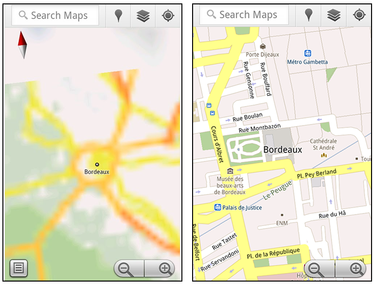
Let’s say later you’re visiting Bordeaux during a trip to France. If you were to open Google Maps for mobile and zoom into Bordeaux without data coverage or wifi, you’d see the image on the left:


Left: Bordeaux with no data or wifi. Right: Bordeaux with downloaded map area

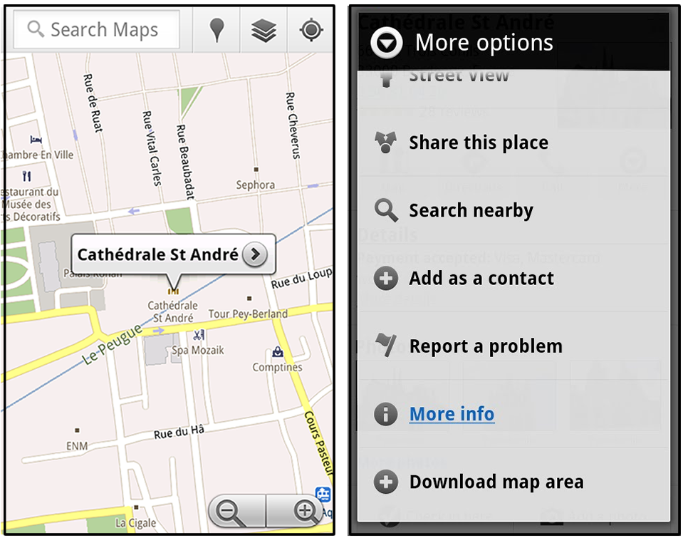
That’s not particularly useful when you’re trying to find out how close you are to the Cathedrale St. Andre. But a little advance planning and “Download map area” can help. Before you take your trip, while you still have access to WiFi or data coverage, you can open up any Places page in the world, click “More” to get the Place page menu, and download Google’s maps for a 10-mile radius.


Left: Tap a landmark to enter its Place page. Right: Place page “more options” menu

The download can take as little as a minute or two. This download stores only the base map tiles and the landmarks on the map, so you still need a data connection to see satellite view and 3D buildings, search for Places and get directions. But we hope the level of detail available will help you find your way!


Left: Status screen for download. Right: Coverage of downloaded map area

All your downloaded map areas can be managed in your Google Maps cache settings so you can delete maps you no longer need or if you want to free up storage. After 30 days, all downloaded map areas will be removed from your cache; they can be re-downloaded any time.

Scale bar
Google Maps has approximately 20 different zoom levels that range from a 2,000 mile scale to a 20 foot scale. With finger gestures making it really quick and easy to zoom in and out, sometimes it’s not always clear what zoom level you’re at. What might be just a few streets away can be quite a long walk depending on the scale. To help with this, you can turn on a scale bar, which updates based on your zoom level.


Scale bar in the lower left

Measure
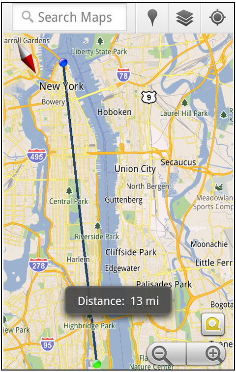
If you ever need to know the distance between San Francisco and New York (about 2602 miles) or between any other two points on the map, the “Measure” lab can help you out. Once it’s enabled, you’ll notice a tape measure icon just above the zoom buttons. After clicking that icon, you’ll be prompted to tap two points on the map and Google Maps will calculate the straight distance between those points (this direct distance is “as the crow flies”).


Example of the “Measure” Labs feature

To access Labs on your phone, press your phone’s menu button once in Google Maps, choose “More” and select Labs. On a tablet, click the menu button in the upper-right corner of Maps. The “Download map area” lab requires Android 2.1+ and the latest version of Google Maps. We look forward to bringing you more experimental features soon and hope you enjoy trying out Labs in Google Maps for Android.

Jul 6, 2011

Google Maps 5.7 for Android introduces Transit Navigation (Beta) and more

(Cross-posted on the Google Lat Long Blog and the Google Mobile Blog)

Today we’re releasing Google Maps 5.7 for Android. From Bangkok to Baltimore, we’ve added Transit Navigation (Beta), updated access to directions, better suggested search results and a photo viewer to Place pages—all of which can help you whether you’re traveling to an unfamiliar part of town or visiting a city across the world.

Transit Navigation (Beta)
Google Maps Navigation (Beta) currently provides over 12 billion miles of GPS-guided driving and walking directions per year. Now, GPS turn-by-turn (or in this case, stop-by-stop) navigation is available for public transit directions in 400+ cities around the globe with Transit Navigation.


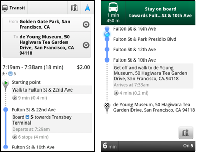
Transit Navigation uses GPS to determine your current location along your route and alerts you when it’s time to get off or make a transfer. This is particularly helpful if you’re in a city where you don’t speak the language and can’t read the route maps or understand the announcements. After starting your trip with Transit Navigation, you can open another application or put your phone away entirely and Google Maps will still display an alert in your notification bar and vibrate your phone when your stop is coming up.


Left: Transit directions without Navigation. Right: with Navigation


Navigation alerts appear even if you switch to another app

Now you can spend more time enjoying the sights out the window and less time worrying about how many stops are left, where you are along the route or whether you missed your stop. Since Transit Navigation relies on GPS signals, we recommend using this feature for above-ground transit.

Updated Directions
Now that we’ve improved our directions services, we wanted them to be incredibly easy to pull up on your screen. If you select the driving or walking icon and your route is supported by Google Maps Navigation, the Navigation icon will automatically appear so you can get access to step-by-step directions in one click. Note: this change is currently only in place for driving and walking and does not appear for public transit.


One-click access to Navigation from directions

We’ve also streamlined how you access directions from within a Place page. Before, clicking directions in a Place page would bring up options for “Driving Navigation,” “Walking Navigation” and “Directions.” Now, you’ll be taken straight to the map and see the new directions box shown above.

Improved Search Suggest
We’ve made two changes to search suggestions that improve their quality and speed. First, we’ve added category icons, so instead of all search suggestions displaying the same icon, the icon next to the listing will reflect the type of result. You’ll see a pin for a Google Places listing, a star for a starred Place or location, a clock for a previously used search term, a person for contacts and a magnifying glass for “anything else.”


Two examples of search suggest with new icons

Also, any place you got directions to or called directly from its Places page will be included as a suggestion for a relevant search. For example, if you recently received directions to the U.S. Post Office on Wilshire Boulevard, afterward, when you begin a search with [p] or [bou], that U.S. Post Office would appear as a search suggestion.

Photo viewer for Place pages
Since we released business photos for Place pages last October, millions of photos have been added to Place pages around the world. To enable you to view these photos on the run, a slick new photo viewer has been added so you can browse photos while deciding where to go.


Left: Business photos in Place pages. Right: New photo viewer

To start using Google Maps 5.7 for Android, download the update here. This update requires an Android OS 2.1+ device and works anywhere Google Maps is currently available. Learn more at our help center and have fun exploring, whether it be by car, transit, bike or foot.